Geography of Vojvodina
Vojvodina is an autonomous region within Serbia located in the Pannonian plain, a region of central Europe. It shares borders with Romania in the east, Hungary in the north, Croatia in the west, and Bosnia and Herzegovina in the southwest. The southern border is administrative line to Šumadija and Western Serbia, Belgrade, and Southern and Eastern Serbia.

Vojvodina general map

Map showing main geographical regions in Vojvodina, as well as cities and towns.

Geographical-historical borders of Vojvodina and geographical sub-regions in Vojvodina

Detailed map of the south-eastern part of Pannonian Sea (modern territory of Vojvodina) during the Miocene Epoch.
Geographical regions of Vojvodina
Mountains and hills
- Fruška Gora
- Titelski Breg
- Vršački Breg
- Zagajička Brda
Sands
- Deliblatska Peščara
- Subotičko-Horgoška Peščara
Rivers
- Danube
- Tisa
- Sava
- Begej
- Tamiš
- Karaš
- Zlatica
- Nera
- Bosut
- Krivaja
- Čik
- Mostonga
- Plazović
Canals
- Canal Danube-Tisa-Danube, and some larger canals part of DTD system:
- Begej canal
- Jegrička canal
- Jarčina canal
Lakes and bogs
- Palićko lake
- Ludoško lake
- Ledinačko lake
- Rusanda lake
- Obedska bog
Gallery
 A landscape from Vojvodina, near the village of Skorenovac
 Canal Danube-Tisa-Danube near the village of Rumenka, close to Novi Sad
 Lake Ledinci on Fruška Gora
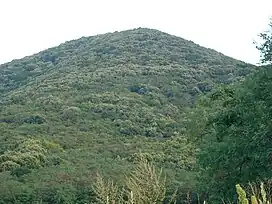 The highest point in Vojvodina
 Typical plains landscape of Vojvodina
External links
Wikimedia Commons has media related to Geography of Vojvodina.
This article is issued from Wikipedia. The text is licensed under Creative Commons - Attribution - Sharealike. Additional terms may apply for the media files.