60th parallel north
The 60th parallel north is a circle of latitude that is 60 degrees north of Earth's equator. It crosses Europe, Asia, the Pacific Ocean, North America, and the Atlantic Ocean.
.svg.png.webp)
Although it lies approximately twice as far away from the Equator as from the North Pole, the 60th parallel is half as long as the Equator line, due to the cosine of 60 degrees being 0.5. This is where the Earth bulges halfway as much as on the Equator.
At this latitude, the Sun is visible for 18 hours, 52 minutes during the June solstice and 5 hours, 52 minutes during the December solstice.[1] The maximum altitude of the Sun is 53.44° on 21 June and 6.56° on 21 December. The maximum altitude of the Sun is > 15.00º in October and > 8.00º in November. [2]
The lowest latitude where white nights can be observed is approximately on this parallel.
During the summer solstice, nighttime does not get beyond nautical twilight, a condition which lasts throughout the month of June. It is possible to view both astronomical dawn and dusk every day between August 22 and April 21.
Around the world
Malachy Tallack wrote a book, Sixty Degrees North: Around the World in Search of Home, about his travels along the general line of the parallel, starting and finishing at Shetland.[3][4]
Starting at the Prime Meridian and heading eastwards, the parallel 60° north passes through:
Co-ordinates Country, territory or ocean Notes 60°0′N 0°0′E Atlantic Ocean North Sea 60°0′N 5°3′E  Norway
Islands of Stolmen and Selbjørn, Hordaland 60°0′N 5°12′E Atlantic Ocean Bekkjarviksundet, Selbjørnsfjorden, North Sea 60°0′N 5°15′E NorwayIsland of Huftarøy, Hordaland 60°0′N 5°17′E Atlantic Ocean Langenuen, North Sea 60°0′N 5°22′E NorwayIslands of Reksteren, Tysnesøy and the mainland Hordaland 60°0′N 5°52′E Atlantic Ocean Hardangerfjorden, North Sea 60°0′N 5°59′E NorwayMainland: Folgefonna glacier, Telemark, Buskerud, Akershus, Oslo, Hedmark, Østfold
Passing just north of the capital Oslo60°0′N 12°23′E  Sweden
Passing through Fagersta
Passing just north of Uppsala60°0′N 18°53′E Atlantic Ocean Baltic Sea 60°0′N 20°8′E  Finland
Högskär, Bäckö and several smaller islands,  Åland Islands
60°0′N 20°58′E Atlantic Ocean Baltic Sea 60°0′N 23°30′E FinlandPassing through Ekenäs 60°0′N 23°58′E Atlantic Ocean Baltic Sea 60°0′N 24°26′E FinlandPorkkala peninsula 60°0′N 24°30′E Atlantic Ocean Baltic Sea, Gulf of Finland
Passing just south of Helsinki, Finland and the island of Gogland,  Russia
60°0′N 27°48′E RussiaMoshchny Island 60°0′N 27°54′E Atlantic Ocean Gulf of Finland, Baltic Sea 60°0′N 29°44′E RussiaIsland of Kotlin (city of Kronstadt) 60°0′N 29°47′E Atlantic Ocean Gulf of Finland, Baltic Sea 60°0′N 30°5′E RussiaPassing through Saint Petersburg, Lake Ladoga 60°0′N 154°30′E Pacific Ocean Shelikhov Gulf, Sea of Okhotsk 60°0′N 161°28′E RussiaKamchatka Peninsula 60°0′N 165°14′E Pacific Ocean Bering Sea 60°0′N 166°10′E RussiaPylgin Range 60°0′N 166°33′E Pacific Ocean Olyutor Gulf, Bering Sea 60°0′N 170°9′E RussiaOlyutor Peninsula 60°0′N 170°26′E Pacific Ocean Bering Sea 60°0′N 167°8′W .png.webp) United States
United StatesAlaska - Nunivak Island 60°0′N 165°39′W Pacific Ocean Etolin Strait, Bering Sea 60°0′N 164°9′W United StatesAlaska 60°0′N 152°38′W Pacific Ocean Cook Inlet, Gulf of Alaska 60°0′N 151°44′W United StatesAlaska - Kenai Peninsula, Evans Island, Elrington Island, Latouche Island and Montague Island 60°0′N 147°24′W Pacific Ocean Gulf of Alaska 60°0′N 144°24′W United StatesAlaska - Wingham Island, Kayak Island and a small section of mainland 60°0′N 143°50′W Pacific Ocean Gulf of Alaska 60°0′N 141°53′W United StatesAlaska 60°0′N 139°3′W .svg.png.webp) Canada
CanadaYukon / British Columbia border
Northwest Territories / British Columbia border
Northwest Territories / Alberta border - passes through Wood Buffalo National Park and beside Fort Smith, NT
Northwest Territories / Saskatchewan border
Nunavut / Manitoba border60°0′N 94°49′W Arctic Ocean Hudson Bay
Passing just north of the Ottawa Islands, Nunavut, Canada60°0′N 77°17′W CanadaQuebec
Passing just south of Puvirnituq, Quebec60°0′N 69°46′W Arctic Ocean Ungava Bay
Passing just south of Kangirsuk, Quebec, Canada60°0′N 65°7′W CanadaQuebec, Newfoundland and Labrador 60°0′N 64°9′W Atlantic Ocean Border between the Davis Strait (to the north) and the Labrador Sea (to the south)[5] 60°0′N 44°52′W  Greenland
Passing just south of Narsaq 60°0′N 43°9′W Atlantic Ocean 60°0′N 1°21′W  United Kingdom
Islands of Mainland and Mousa, Shetland Islands,  Scotland
60°0′N 1°11′W Atlantic Ocean North Sea
Notable cities and towns on 60°N
- Whitehorse, Yukon, Canada
- Bergen, Vestland, Norway
- Oslo, Norway
- Helsinki, Uusimaa, Finland
- Espoo, Uusimaa, Finland
- Saint Petersburg, Russia
Canada
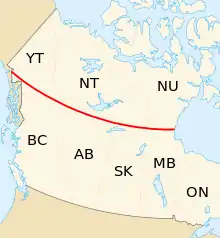
In Canada, the 60th parallel forms the southern mainland boundary of the northern territories of Yukon, Northwest Territories, and Nunavut with the western provinces of British Columbia, Alberta, Saskatchewan, and Manitoba.
Accordingly, "north of 60" is an expression often used for the territories, although parts of Nunavut (the islands in Hudson Bay and James Bay) are located south of the 60th parallel, and parts of Quebec and Newfoundland and Labrador are located north, to the east of Hudson Bay. A 1990s TV show on CBC about life in the Northwest Territories was called North of 60.
The 60th Parallel Territorial Park is on Mackenzie Highway between Alberta and Northwest Territories and it has a visitor centre there in the homeland of the Yellowknives Dene First Nation and the North Slave Métis Alliance.[6]
Canada's only four corners are located at the intersection of the 60th parallel and the 102nd meridian west, between the Northwest Territories, Nunavut, Saskatchewan, and Manitoba.
Greenland
Between 1776 and 1950, the 60th parallel formed the southern limit of the Royal Greenland Trade Department's exclusive monopoly on trade near the Dano-Norwegian and later Danish colonies of Greenland (1776–1782) and South Greenland (1782–1950).[7]
See also
References
- "Duration of Daylight/Darkness Table for One Year". U.S. Naval Observatory. 2019-09-24. Archived from the original on 2019-10-12. Retrieved 2021-03-10.
- NASA. "Earth Fact Sheet". Retrieved April 11, 2017.
- Self, Will (8 July 2015). "60 Degrees North by Malachy Tallack review – around the world in search of home". The Guardian.
- Tallack, Malacky (2017). Sixty Degrees North: Around the World in Search of Home. Pegasus Books. ISBN 9781681774619.
- "Limits of Oceans and Seas, 3rd edition" (PDF). International Hydrographic Organization. 1953. Archived from the original (PDF) on 8 October 2011. Retrieved 28 December 2020.
- "60th Parallel Visitor Information Centre". Spectacular NWT. Northwest Territories Tourism. Retrieved 30 January 2024.
- Marquardt, Ole. "Change and Continuity in Denmark's Greenland Policy" in The Oldenburg Monarchy: An Underestimated Empire?. Verlag Ludwig (Kiel), 2006.
Circles of latitude / meridians | |
|---|---|

45x90
45x90
45x90
45x90
|