Takab County
Takab County, or Tekab County (Persian: شهرستان تکاب) is in West Azerbaijan province, Iran. Its capital is the city of Takab.[3]
Takab County
Persian: شهرستان تکاب | |
|---|---|
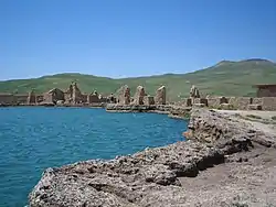 Takht-e-Soleiman World Heritage Site | |
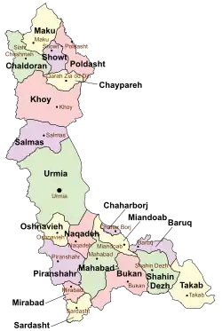 Location of Takab County in West Azerbaijan province (bottom right, yellow) | |
 Location of West Azerbaijan province in Iran | |
| Coordinates: 36°32′N 47°08′E[1] | |
| Country | |
| Province | West Azerbaijan |
| Capital | Takab |
| Districts | Central, Takht-e Soleyman |
| Population (2016)[2] | |
| • Total | 80,556 |
| Time zone | UTC+3:30 (IRST) |
| Takab County can be found at GEOnet Names Server, at this link, by opening the Advanced Search box, entering "9205907" in the "Unique Feature Id" form, and clicking on "Search Database". | |
Demographics
Ethnicity and religion
About 65% of the population of the county are Shia Azerbaijanis and 35% are Sunni Kurds.[4]
Population
At the time of the 2006 National Census, the county's population was 81,395 in 17,618 households.[5] The following census in 2011 counted 78,122 people in 20,184 households.[6] At the 2016 census, the county's population was 80,556 in 23,482 households.[2]
Administrative divisions
Takab County's population history and administrative structure over three consecutive censuses are shown in the following table.
| Administrative Divisions | 2006[5] | 2011[6] | 2016[2] |
|---|---|---|---|
| Central District | 58,399 | 56,564 | 60,459 |
| Afshar RD | 4,265 | 3,814 | 3,335 |
| Ansar RD | 5,846 | 4,918 | 4,242 |
| Karaftu RD | 4,586 | 3,792 | 3,205 |
| Takab (city) | 43,702 | 44,040 | 49,677 |
| Takht-e Soleyman District | 22,996 | 21,558 | 20,097 |
| Ahmadabad RD | 11,096 | 10,120 | 10,259 |
| Chaman RD | 3,410 | 3,325 | 2,650 |
| Saruq RD | 8,490 | 8,113 | 7,188 |
| Total | 81,395 | 78,122 | 80,556 |
| RD = Rural District | |||
References
- OpenStreetMap contributors (19 February 2024). "Takab County" (Map). OpenStreetMap. Retrieved 19 February 2024.
- "Census of the Islamic Republic of Iran, 1395 (2016)". AMAR (in Persian). The Statistical Center of Iran. p. 04. Archived from the original (Excel) on 30 August 2022. Retrieved 19 December 2022.
- Habibi, Hassan (24 September 1369). "Creation and establishment of two cities and several districts and annexation of several villages to Urmia city". Research Center of the System of Laws of the Islamic Council of the Farabi Library of Mobile Users (in Persian). Ministry of Interior, Defense Political Commission of the Government Board. Archived from the original on 23 February 2014. Retrieved 20 December 2023.
- Mashhad Ferdowsi University: تأثیر هویت مکانی بر توزیع فضایی رأی در حوزه انتخابیه میاندوآب، شاهیندژ و تکاب: در شهرستان شاهین دژ نسبت ترکیب جمعیت کرد ۳۰٪ و ترک ۷۰٪ و این ترکیب جمعیت در شهرستان تکاب ۳۵٪ به ۶۵٪ است.
- "Census of the Islamic Republic of Iran, 1385 (2006)". AMAR (in Persian). The Statistical Center of Iran. p. 04. Archived from the original (Excel) on 20 September 2011. Retrieved 25 September 2022.
- "Census of the Islamic Republic of Iran, 1390 (2011)". Syracuse University (in Persian). The Statistical Center of Iran. p. 04. Archived from the original (Excel) on 20 January 2023. Retrieved 19 December 2022.
West Azerbaijan province, Iran | ||
|---|---|---|
| Capital |
|  |
| Counties and cities |
| |
| Tourism |
| |
| Places | ||
| Capital |
| ||||||||||||||
|---|---|---|---|---|---|---|---|---|---|---|---|---|---|---|---|
| Districts |
| ||||||||||||||
This article is issued from Wikipedia. The text is licensed under Creative Commons - Attribution - Sharealike. Additional terms may apply for the media files.