Western Visayas
Western Visayas (Hiligaynon: Kabisay-an Nakatundan; Tagalog: Kanlurang Kabisayaan or Kanlurang Visayas) is an administrative region in the Philippines, numerically designated as Region VI. It consists of five provinces: Aklan, Antique, Capiz, Guimaras, and Iloilo. The region also includes one highly urbanized city, Iloilo City, which is the largest city and serves as the regional center.[3]
Western Visayas
Kabisay-an Nakatundan Kanlurang Kabisayaan | |
|---|---|
 Location in the Philippines | |
OpenStreetMap | |
| Coordinates: 11°08′N 122°32′E | |
| Country | |
| Island group | Visayas |
| Regional center and largest city | Iloilo City |
| Area | |
| • Total | 12,750.63 km2 (4,923.05 sq mi) |
| Highest elevation (Mount Madja-as) | 2,117 m (6,946 ft) |
| Population | |
| • Total | 4,730,771 |
| • Density | 370/km2 (960/sq mi) |
| Time zone | UTC+8 (PST) |
| ISO 3166 code | PH-06 |
| Provinces | 5
|
| Independent Cities | 1
|
| Component cities | 2
|
| Municipalities | 98 |
| Barangays | 3,209 |
| Cong. districts | 10 |
| Languages |
|
| GDP (2023) | ₱1.024 trillion $18.61 billion[2] |
| Growth rate | |
| HDI | |
| HDI rank | 5th in the Philippines (2019) |


_-_Flickr.jpg.webp)
_(1).jpg.webp)
The Hiligaynon language is the region's lingua franca. The region is also dominated by the native speakers of three Visayan languages: Kinaray-a, Aklanon and Capiznon. The land area of the region is 12,750.63 km2 (4,923.05 sq mi), and with a population of 4,730,771 inhabitants.
On May 29, 2015, the region was realigned, when Western Visayas (Region VI) lost both the province of Negros Occidental and the highly urbanized city of Bacolod to the newly formed Negros Island Region. However, the region was dissolved, resulting in the return of Negros Occidental and Bacolod to Western Visayas Region on August 9, 2017. The region again lost Negros Occidental and Bacolod when the Negros Island Region was reestablished on June 13, 2024.
Etymology
The region's current name is in reference to its geographic position in the greater Visayas area.
History
_w_Borders_n.png.webp)
Regions first came into existence on September 24, 1972, when the provinces of the Philippines were organized into 11 regions by Presidential Decree No. 1 as part of the Integrated Reorganization Plan by President Ferdinand Marcos Sr. The provinces of Aklan, Antique, Capiz, Iloilo (including its then-subprovince of Guimaras), and Negros Occidental were grouped together to form the Western Visayas region.
The province of Palawan was transferred to Region VI (Western Visayas) on May 23, 2005, by Executive Order 429.[4] The Department of the Interior and Local Government announced in June 2005 that the transfer had been completed.[5] However, Palaweños criticized the move, citing a lack of consultation, with most residents in Puerto Princesa City and all municipalities but one preferring to stay with Region IV-B. Consequently, Administrative Order No. 129 was issued on August 19, 2005, to address this backlash. This Order directed the abeyance of Executive Order 429 pending the approval of an implementation plan for the orderly transfer of Palawan from Region IV-B to Region VI.[6]Hence, Palawan is currently still part of Region IV-B.
By virtue of Executive Order No. 183 issued on May 29, 2015, by President Benigno Aquino III, the province of Negros Occidental and its capital, Bacolod, were both removed from Western Visayas in order to form the Negros Island Region along with Negros Oriental.[7] But later regained Negros Occidental and its capital, Bacolod City back into Western Visayas on August 9, 2017, when President Rodrigo Duterte dissolved the Negros Island Region, revoking Executive Order No. 183, s. 2015 through the signage of Executive Order No. 38, citing the reason of the lack of funds to fully establish the NIR according to Benjamin Diokno, the Secretary of Budget and Management.[8]
On June 13, 2024, the region again lost Negros Occidental and Bacolod when the Negros Island Region was reestablished under Republic Act No. 12000 signed by President Ferdinand Marcos Jr.[9]
Geography
Western Visayas consists of the major island of Panay and the smaller Guimaras, as well as several outlying islands. The region is bordered to the north by the Sibuyan Sea, northeast by the Visayan Sea, southeast by the island of Negros, south by the Iloilo Strait and Panay Gulf, and west by the Sulu Sea.
Provinces
Western Visayas consists of 5 provinces, 1 highly urbanized city, 2 component cities, 98 municipalities and 3,209 barangays.
| Province or HUC | Capital | Population (2020)[1] | Area[10] | Density | Cities | Muni. | Barangay | |||||
|---|---|---|---|---|---|---|---|---|---|---|---|---|
| km2 | sq mi | /km2 | /sq mi | |||||||||
| Aklan | Kalibo | 7.7% | 615,475 | 1,760.30 | 679.66 | 350 | 910 | 0 | 17 | 327 | ||
| Antique | San Jose de Buenavista | 7.7% | 612,974 | 2,730.67 | 1,054.32 | 220 | 570 | 0 | 18 | 590 | ||
| Capiz | Roxas | 10.1% | 804,952 | 2,594.64 | 1,001.80 | 310 | 800 | 1 | 16 | 473 | ||
| Guimaras | Jordan | 2.4% | 187,842 | 611.87 | 236.24 | 310 | 800 | 0 | 5 | 98 | ||
| Iloilo | Iloilo City | 25.8% | 2,051,899 | 4,997.64 | 1,929.60 | 410 | 1,100 | 1 | 42 | 1,721 | ||
| Iloilo City | † | — | 5.8% | 457,626 | 78.34 | 30.25 | 5,800 | 15,000 | — | — | 180 | |
| Total | 4,730,771 | 12,750.63 | 4,923.05 | 370 | 960 | 2 | 98 | 3,209 | ||||
| ||||||||||||
Governors and vice governors
| Province | Image | Governor | Political Party | Vice Governor | |
|---|---|---|---|---|---|
 |
Jose Enrique Miraflores | PDP–Laban | Reynaldo Quimpo | ||
 Antique |
 |
Rhodora Cadiao | NUP | Edgar Denosta | |
Capiz |
 |
Fredenil Castro | Lakas | James Magbanua | |
Guimaras |
 |
Joaquin Carlos Rahman Nava | NUP | John Edward Gando | |
 Iloilo |
 |
Arthur Defensor Jr. | NUP | Christine Garin | |
Cities
- † Regional center
| City | Population (2020)[1] | Area | Density | City class | Income class | Province | ||
|---|---|---|---|---|---|---|---|---|
| km2 | sq mi | /km2 | /sq mi | |||||
| † Iloilo City | 457,626 | 78.34 | 30.25 | 5,800 | 15,000 | Highly urbanized | 1st | Iloilo |
| Passi | 88,873 | 251.39 | 97.06 | 350 | 910 | Component | 4th | Iloilo |
| Roxas | 179,292 | 95.07 | 36.71 | 1,900 | 4,900 | Component | 1st | Capiz |
Demographics
| Year | Pop. | ±% p.a. |
|---|---|---|
| 1903 | 1,083,474 | — |
| 1918 | 1,347,249 | +1.46% |
| 1939 | 2,173,579 | +2.30% |
| 1948 | 2,530,517 | +1.70% |
| 1960 | 3,078,305 | +1.65% |
| 1970 | 3,618,326 | +1.63% |
| 1975 | 4,146,390 | +2.77% |
| 1980 | 4,525,615 | +1.77% |
| 1990 | 5,393,333 | +1.77% |
| 1995 | 5,776,938 | +1.30% |
| 2000 | 6,211,038 | +1.57% |
| 2007 | 6,843,643 | +1.35% |
| 2010 | 7,102,438 | +1.36% |
| 2015 | 7,536,383 | +1.14% |
| 2020 | 7,954,723 | +1.07% |
| Data in 2015 includes Negros Occidental and Bacolod. Source: Philippine Statistics Authority[11][12] | ||
Languages
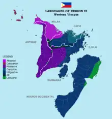
The native languages of Western Visayas are:
- Aklanon/Akeanon, spoken in Aklan and northwestern Capiz.
- Capiznon, spoken in Capiz, northeastern Iloilo, and eastern Aklan.
- Hiligaynon, spoken in Iloilo, Guimaras, Capiz, Antique, and Aklan. It is the regional lingua franca.
- Kinaray-a, spoken in Antique, southwestern half of Iloilo, Guimaras, western Capiz, and southwestern Aklan.
- Malaynon, spoken in northwestern Aklan including Boracay Island.
- Caluyanon, spoken in the Semirara Islands (Semirara, Caluya, and Sibay Islands).
Economy
.jpg.webp)
Poverty incidence of Western Visayas
10
20
30
40
2006
29.08 2009
30.80 2012
29.14 2015
24.60 2018
16.32 2021
13.80 Source: Philippine Statistics Authority[13][14][15][16][17][18][19][20] |
Western Visayas is the sixth largest economy in the Philippines.[21] Iloilo City serves as the region's economic hub. Other major trading and commercial centers in the region include Roxas City in Capiz, San Jose in Antique, and Kalibo in Aklan. Metro Iloilo, composed of Iloilo City and the municipalities of Oton, San Miguel, Pavia, Leganes, Santa Barbara, and Cabatuan, along with the island province of Guimaras, is the center for commercial, financial, and industrial activities in the region.
Transportation
Airports

International
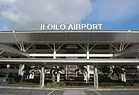
- Iloilo International Airport
- Kalibo International Airport
Domestic
- Godofredo P. Ramos Airport (Caticlan, Malay, Aklan)
- Roxas Airport (Roxas City, Capiz)
- Evelio Javier Airport (Funda-Dalipe, San Jose de Buenavista, Antique)
Municipal
- Semirara Airport (Semirara Island, Caluya, Antique)
Other
- Sicogon Airport (Sicogon Island, Carles, Iloilo)
- Guimaras Airport (Buenavista, Guimaras)
Rail
Proposals to re-connect again Iloilo-Roxas, Iloilo-Kalibo, Iloilo-Malay (Aklan) and Iloilo-San Jose (Antique) from the Iloilo City via rail was included in the revival of the currently defunct Panay Railways network which has a station in Santa Barbara town proper.[22]
References
- Census of Population (2020). "Region VI (Western Visayas)". Total Population by Province, City, Municipality and Barangay. Philippine Statistics Authority. Retrieved July 8, 2021.
- "2021 to 2023 Gross Regional Domestic Product (GRDP)". openstat.psa.gov.ph. Philippine Statistics Authority. Retrieved April 26, 2024.
- "History of Urban Growth of Iloilo City". Iloilo City Government. Archived from the original on June 30, 2012. Retrieved June 28, 2012.
- President of the Philippines. "Executive order No. 429". Office of the Press Secretary. Archived from the original on July 7, 2007.
- "Palawan, Puerto Princesa Transfer to Region VI" (Press release). Government of the Philippines. June 3, 2005.
- President of the Philippines (August 19, 2005). "Administrative Order No. 129". Office of the Press Secretary. Archived from the original on July 13, 2006.
- "Executive Order No. 183, s. 2015". Official Gazette (Philippines). May 29, 2015. Retrieved June 5, 2015.
- "Duterte dissolves Negros Island Region". Rappler. August 9, 2017. Retrieved August 10, 2017.
- "Marcos signs law creating Negros Island Region". ABS-CBN. June 13, 2024. Retrieved June 13, 2024.
- "PSGC Interactive; List of Provinces". Philippine Statistics Authority. Archived from the original on July 11, 2016.
- Census of Population (2015). "Region VI (Western Visayas)". Total Population by Province, City, Municipality and Barangay. Philippine Statistics Authority. Retrieved June 20, 2016.
- "Population and Annual Growth Rates for The Philippines and Its Regions, Provinces, and Highly Urbanized Cities" (PDF). 2010 Census and Housing Population. Philippine Statistics Authority. Archived from the original (PDF) on September 28, 2013. Retrieved August 9, 2013.
- "Poverty incidence (PI):". Philippine Statistics Authority. Retrieved December 28, 2020.
- "Estimation of Local Poverty in the Philippines" (PDF). Philippine Statistics Authority. November 29, 2005.
- "2009 Official Poverty Statistics of the Philippines" (PDF). Philippine Statistics Authority. February 8, 2011.
- "Annual Per Capita Poverty Threshold, Poverty Incidence and Magnitude of Poor Population, by Region and Province: 1991, 2006, 2009, 2012 and 2015". Philippine Statistics Authority. August 27, 2016.
- "Annual Per Capita Poverty Threshold, Poverty Incidence and Magnitude of Poor Population, by Region and Province: 1991, 2006, 2009, 2012 and 2015". Philippine Statistics Authority. August 27, 2016.
- "Annual Per Capita Poverty Threshold, Poverty Incidence and Magnitude of Poor Population, by Region and Province: 1991, 2006, 2009, 2012 and 2015". Philippine Statistics Authority. August 27, 2016.
- "Updated Annual Per Capita Poverty Threshold, Poverty Incidence and Magnitude of Poor Population with Measures of Precision, by Region and Province: 2015 and 2018". Philippine Statistics Authority. June 4, 2020.
- "2021 Full Year Official Poverty Statistics of the Philippines" (PDF). Philippine Statistics Authority. August 15, 2022. Retrieved April 28, 2024.
- "Tables | Philippine Statistics Authority | Republic of the Philippines". psa.gov.ph. Retrieved June 14, 2024.
- Salvilla, Rex S. (July 28, 2006). "Anything Under the Sun: Panay Railways". The News Today. TNT Publishing, Inc. Retrieved June 12, 2008.
External links
 Media related to Western Visayas at Wikimedia Commons
 Western Visayas travel guide from Wikivoyage
 Geographic data related to Western Visayas at OpenStreetMap
Places adjacent to Western Visayas | ||||||||||||||||
|---|---|---|---|---|---|---|---|---|---|---|---|---|---|---|---|---|
| ||||||||||||||||
| Regional center |
|  |
|---|---|---|
| Provinces |
| |
| Metropolitan Areas |
| |
| Highly urbanized cities |
| |
| Component cities |
| |
| Provincial capitals |
| |
| Municipalities |
| |
Visayas, Republic of the Philippines | ||